These awe-inspiring scenes of water frothing and churning through moss-covered canyons are among nature’s most remarkable spectacles. In the art – or adventure – of chasing waterfalls, the Kootenays are home to an extraordinary abundance, making the choice of which to explore a delightful challenge. Below is a curated list of hidden waterfalls, presented in alphabetical order. Happy waterfall chasing in the Birthplace of Adventure.
Bear Creek Falls
Located between Golden & Revelstoke – Expect a wet spray while you descent down the wooden steps to the 100-metre falls.
(Location: At the east end of the parking area, there is a large sign about services in Glacier National Park. And just right of the sign is a completely unmarked, but well-maintained trail that descends into the forest. This easy hiking trail is a great opportunity to stretch your legs when travelling on the Trans-Canada Highway. The trail is only accessible if you are heading east on Hwy #1 from the summit of the Rogers Pass. From the summit, drive east for 13.3 km to a small turnout that has a viewpoint with an arrow indicating 200-metres.)
Beaver Creek Falls
In the late summer this is a popular swimming hole, near Fruitvale/Trail, offers a dramatic plunge through the steep canyon is mesmerizing.
(Location: It is recommended to take the Falls Road East off the Highway 3B in Beaver Falls and follow it to the end. The path leads down to the bridge/waterfall).
Begbie Falls
Begbie Falls is a small falls at the mouth of Begbie Creek on the Upper Arrow Lake, south of Revelstoke.
(Location: This site is located at the end of the Begbie Falls Forest Service Road (FSR). Access the site by vehicle on Begbie Falls FSR or trail access from the Begbie Bluffs Parking area on Highway 23 via the Bluff Trail. The trail is a shared multi-use trail, mountain bikers please dismount and yield to all other users.)
Bugaboo (Lower) Creek Falls
The easy trail begins next to the Forestry Recreation road and is a nice stroll past old fir trees. At 1.1-km, follow the obvious trail down to the creek’s edge, where you get a good view of the 100-metre falls from downstream.
(Location: On Hwy 95 near Spillimacheen/Brisco, turn right on the Westside Road and cross the Columbia River valley. After 2.3 km, turn on the Westside Road, do not take the Giant Mine Road. Follow the Westside Road for another 3.9 km, which will take you across Bugaboo Creek and up a steep hill with a switchback. Near the top of the hill, look for the old Forestry recreation trail sign for Lower Bugaboo Falls. If you reach the 8-kilometre sign, you’ve good about 300 metres too far.)
** The Upper Bugaboo Creek Falls are right next to the Bugaboo Forest Service Road; however, the drive to these from Hwy 95 is approximately 55+ kms (one-way).
Cherry Creek Falls
This falls are located in the Cherry Creek Regional Park in Meadowbrook, just a short drive from Kimberley, BC. There is a large parking area and a short trail to the falls pass a few picnic benches – this it descent down a wooden staircase to the bottom of the falls. Here you can watch spawning fish try to jump up the falls or enjoy a quick cool plunge into a small swimming pool.
(Location: Going east from Kimberley on Highway 95A. Turn left to go north onto Thomason Road. Follow for 400 m. Turn right to go north on Clarricoates Road. Stay on road for 1.8 km and the park will be on your right. (Clarricoates Road will turn into Ta Ta Lost Dog Forest Service Road.)
Glade Falls
You will be pleasantly surprised by this hidden waterfall near the Glade Ferry crossing.
(Location: After disembarking the Glade ferry, drive up to turn right onto Glade Road and reset the odometer if needed. Drive 1.4-km. Continue driving and cross Glade Creek. Fork left at 1.7-km – at the 1.7 km mark there is a parking area, we recommend that you park here. Or you can continue up the hill the additional 0.4-km to the 2.1-km mark, to park along-side the road.
**Please be aware of private property and respect those who live nearby. You’ll hear Glade Creek Falls from this point. Look for the path leading away from the road towards the waterfall noise. It’s just a short walk up to the waterfall.
**Be cautious if you venture out onto the wet slippery rocks below the falls for a closer look or a photo.)
Ione Falls
This are tucked away from the sight of Highway #23, just north of Nakusp BC (19-km). But as you enter the rest stop, you will be greeted by this lovely falls. Expect to get wet from the spray at the base of the waterfall (18-metre) when the water flow is high.
(Location: Rest stop on Highway #23 near Nakusp, BC.)
Josephine Falls
These breath-taking falls cascade 25 metres down a steep canyon carved by the Fording River. This striking waterfall was discovered in 1905 by Professor Henry F. Osborn and his family and named in honour of Miss Josephine Osborn, who caught the largest trout thus far recorded from that spot.
(From Sparwood, take Highway 43 north to Elkford. At the 4-way stop turn right and drive the paved Greenhills Mine Road for 5.1 km until you see a Forest, Falls and Lakes trails — this is your trailhead. Proceed to the Falls which are about 2.3 km one-way.)
Kay Falls
A very short trek (150-m) leads to these road side waterfalls along the Trans-Canada Highway, heading west.
(Location: Drive west on Hwy 1, just past the Enchanted Forest, west of Revelstoke, and look for a small pullout on the south side of the highway. Better to hit the pullout going east. Park well clear of the highway. It’s a five-minute walk to the falls.)
Laughing/Twin Falls
Just past Takakkaw Falls (popular and one of Canada’s highest waterfalls) is the Yoho Valley Road and access to two waterfalls, Laughing and Twin Falls. It’s an easy trek to Laughing Falls and if you continue on the same trail it will bring you to Twin Falls and the historic Twin Falls Chalet (also known as the Twin Falls Tea House). The Twin Falls Tea House was designated a National Historic Site of Canada in 1992.
(Location: The trail is one way, 4.4 km, to Laughing Falls campground from the parking lot in the Yoho Valley, via the Takakkaw Falls parking lot.)
Little McPhee Creek
This was the original Doukhobor workers’ trail from Brilliant Dam. The trail drops into the creek bed, which is followed upstream for a short distance. A short extension of the trail ends at the plunge pool of the scenic waterfall.
(Location: There are two entrances to the waterfalls, these directions are from Brilliant Substation Parking Lot. The one-way trek to the falls are 2.3-km. Leave Castlegar heading towards Nelson on Hwy 3A.Before the Brilliant bridge, turn right on Ootischenia Road and head up the hill. Follow signs to the golf course, turn left on Corrigan Road turning into Columbia Road. Turn left on Aaron Road. Turn right on gravel road with gate before the golf course, note gate closure times, and follow for 4km, keep left at 2-km fork in road. Turn left into parking lot before the Substation. Follow Skattebo Reach trail for 2.25-km passing the Brilliant Overlook and Doukhobor Waterline trailheads. Turn right at Little McPhee Creek Waterfall trail junction.)
Matheson Falls
These falls are just outside of Fernie near the old mining town of Coal Creek. With soft moss-coated rocks surrounding the spectacular cascading waters, it’s virtually impossible to get a bad photo here.
(Location: Drive down Coal Creek Road for approximately 9-km. Once you go past the yellow mileage 41 Marker on your right-hand side, you will cross a small bridge. Immediately, after the bridge, the path starts on your right-hand side. There is a small pull out to the left of the bridge where you can park your car. Follow the path, which runs parallel to the left of the creek. The path will soon end at the water; from there on you will have to walk up the creek. You can find various trail sections on the right of the creek, so I would recommend crossing from the left of the creek to the right to avoid walking in the water the entire time. After about 15-20 minutes of walking, you will end up at the base of Matheson Falls.)
Meachem Falls
These falls are just a short trek from the Meachen Creek Forest Service road, up the St. Mary Valley. You will hear the falls (especially during the spring) before you actually see them.
(Location: From Kimberley take the St. Mary River road to the end of the lake and cross the bridge. Once you reach a fork in the road, turn right onto the Meachen Creek Forest River Road and follow it to the 8-km road sign marker.)
Perry Creek Falls
The trail to these falls is an easy 1.4-km hike, with a descent of 120-m. The trail takes you past an abandoned gold mine to a set of pools below the waterfall itself.
(Location: Head north towards Kimberley on Hwy 95A and turn left at (road to Shadow Mountain Golf Resort) onto the Wycliffe Park Road. Continue on this road until reach the ‘Old Wycliffe Road’, turn left. Proceed about 1 km then turn right on the Perry Creek Road. Follow this road for about 10-km. The trailhead will be on your left.)
Powder Creek Falls
Access to these secluded falls is by boat/kayak. Paddle from the shores of Kaslo across Kootenay Lake. Known by the locals as “Angel Falls”, these are a short trek from the shoreline.
(Location: Paddle across Kootenay Lake to Powder Creek, it’s a short trek to the falls. Don’t have a kayak or boat, check in with Kaslo Kayaking — this is one of their popular excursions.)
Springer Creek Falls
Here you can hike from falls to falls. And these network of trails are open to expert mountain bikers as well. And if you wish to access alpine views of the Slocan Valley, take the 4×4 road on the north side of the creek.
(Location: Start in the camp ground in Slocan and make your way up, across the highway for falls after falls.)
Sutherland Falls
This 12-m high waterfall is located in Blanket Creek Provincial Park. The hike to the falls is short and easy but the reward of this stunning waterfall is worth the detour.
(Location: Drive south of Revelstoke on Highway 23. Turn off the highway at the Blanket Creek Provincial Park. Locate the falls trail Parking lot and walk into the viewpoint.)
Tulip Creek Falls
The short trail, in Syringa Provincial Park near Castlegar, follows Tulip Creek into a stunning canyon, the canyon is decorated with red-stained walls and moss with the intermittent fern adding some stunning colours.
(Location: Drive north across the bridge connecting Castlegar and Robson. Turn left on Broadwater Road into Robson. Follow for 19 km and enjoy the view. Veer right at Syringa Creek Provincial Park and continue up Deer Park Road gravel road for 3.5-km, watch for logging trucks. There is a small parking lot beside the first creek which the gravel road crosses, is where the trailhead begins.)
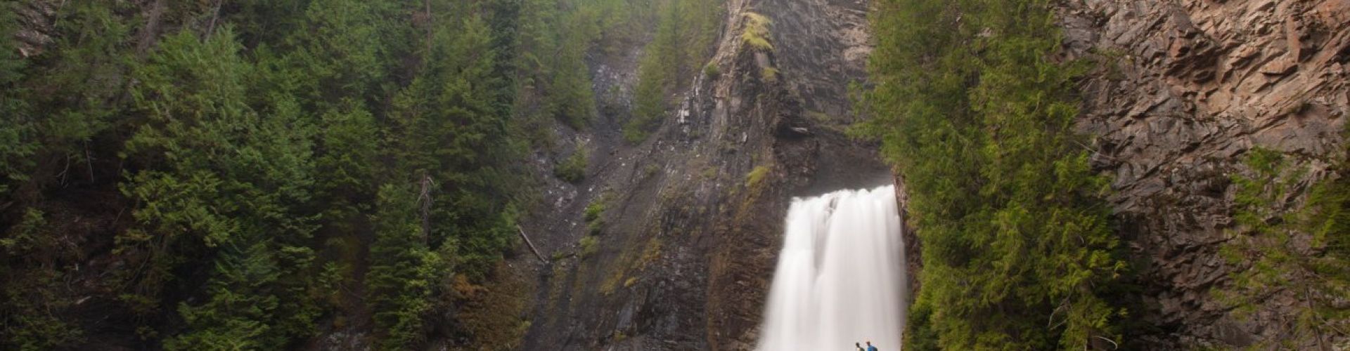
Wilson Creek Falls
The Wilson Creek Falls plunge 63m down into a rocky canyon, ripping with noise and spray. It’s a quick and impressive destination!
(Location: The trailhead is reached up the East Wilson Creek FSR, near Rosebery BC. After driving this good, 2WD LC road for 11.5km, a signed junction points up a rougher road towards the falls. The last 1km of road is rougher and narrow, but should be drivable for all vehicles. The trail is relatively level as it starts to meander through the forest. However, as you near the canyon, the trail steepens significantly into a careful descent. The waterfall can be heard in the distance and is reached within 30 minutes of walking.)
Other Hidden Waterfalls
~ Brisco (north of Radium Hot Springs)
~ Bugaboo Upper Falls (north of Radium Hot Springs)
~ Bull River Falls (near Wardner)
~ Cottonwood Falls (Nelson)
~ Evans Beach/Creek (Valhalla Provincial Park)
~ Fairy Creek (Fernie)
~ Findlay Creek (near Canal Flats)
~ Fletcher Falls (Kaslo)
~ Hamilton Falls (Yoho National Park)
~ Jumping Waters (Fernie/Heiko’s Trail)
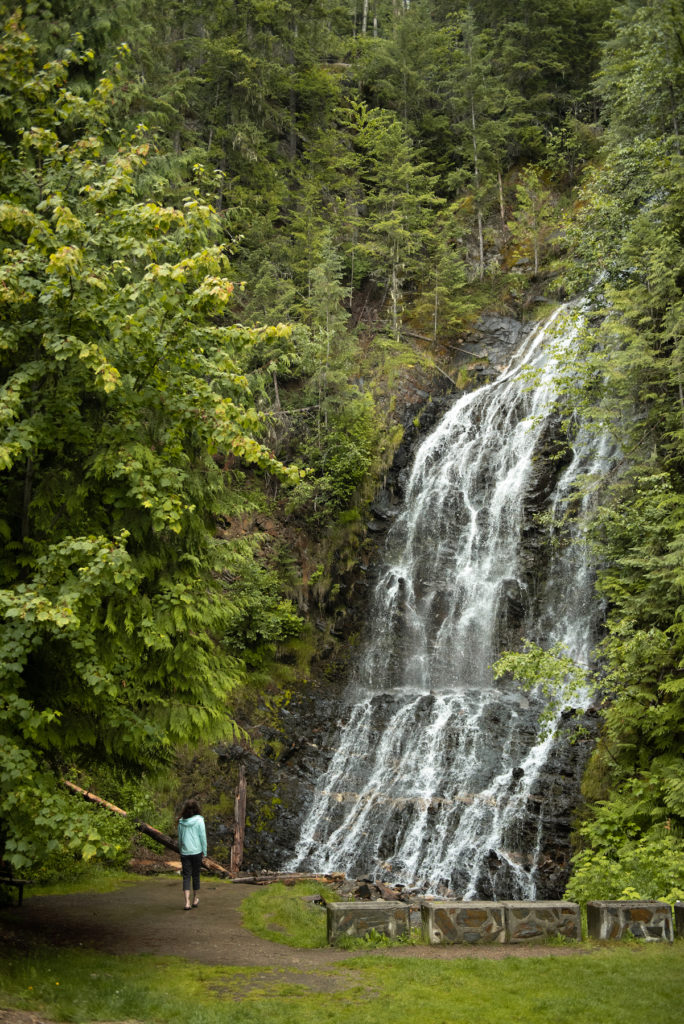
~ Marysville Falls (Kimberley)
~ Moyie/Lumberton Falls (Moyie)
~ Nemo Creek (Slocan Valley)
~ Sinclair Canyon (Radium Hot Springs)
~ Wapta Falls (Yoho National Park)